
Surveyors, theodolites and astronomy have been an integral part of the exploration, mapping and understanding the geography of Antarctica, the last and frozen Frontier on earth.
Now GPS (Global Positioning System) techniques are the modern and fast way to achieve similar, and better, results. Yet it is well to recognise that GPS as an 'astronomy' technique, as the satellites are sub-stellar objects of known position which are observed and computed electronically and very fast.
Captain Cook, surveyor and navigator, circumnavigated the Antarctic Continent in 1773, without having a positive sighting of the continent, but proved that a continent existed. His navigation by sextant and chronometer depended on astronomy.
The first sighting of the Antarctic landmass (and ice) is reliably attributed to Biscoe in 1823. Early reports of sightings, mostly by whaling exploits, are subject to doubt and lack of reliable navigation and encounters with very large icebergs.
In 1899 the first occupation of the continent was by Carsten Borchgrevink and his expedition to Cape Adare. Borchgrevink was a Norwegian, resident of Australia at the time, and he sailed from Hobart in December 1898 and set up his station at Cape Adare and wintered there through 1899. In a varied career, Borchgrevink had spent four years working in Queensland and New South Wales as a Forestry Surveyor. This first wintering is considered an Australian based venture although financed by a British Newspaper owner Sir George Newnes.
This was a beginning of scientific based expeditions on the continent compared with earlier whaling activity. Australian scientist Louis Bernacchi, of Hobart, was an expedition member. He specialized in magnetic and meteorological studies and worked in 1895 on the staff of the Melbourne Observatory.
The famous Scott and Amundsen explorers, competitors in the 1912 expeditions to attain the South Pole, were both using theodolites and astronomy for their navigation. Scott, who arrived at the pole after Amundsen, recorded a difference in the determination of the position of the pole by a matter of half a mile (900metres). This was a good result considering that Scott was using a four inch theodolite graduated to half a minute of arc.
Since 1954, when Australia established Mawson Station, Australia has had a continuous presence on the continent of Antarctica, organised by the Australian National Antarctic Research Expeditions (ANARE). Davis and Casey Stations also operate and the coast of Australian Antarctic Territory has been mapped.
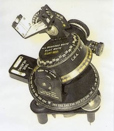
Australian Surveyors developed a technique to enable daylight stars to be located and observed for astrofixes. Astrofixes are taken for recognisable features which can be identified on aerial photography. So solid rock features are preferred for this purpose. A suitable program of star observations is predicted using a star chart (planisphere) and then a time, azimuth and elevation for each star is calculated in the field using tables of computed altitude and azimuth.
With clear skies, the star is found in a correctly pointed telescope using the calculated values. The star is then observed, most commonly for altitude and time, to provide a position line fix. Position Line fixes provided an accuracy within about 100 metres, depending on conditions.
David Carstens was appointed as “Surveyor Mawson 1961” principally to undertake survey work using aircraft, but with the loss of two aircraft, the aerial survey program was not possible. David went to Mawson on a round-trip early in 1961 and later re-joined ANARE to be “Surveyor Mawson 1962” serving there until March 1963. The work described here relates to the use made of astronomy by David which is typical of, but not the same as, that of other ANARE surveyors at that time.
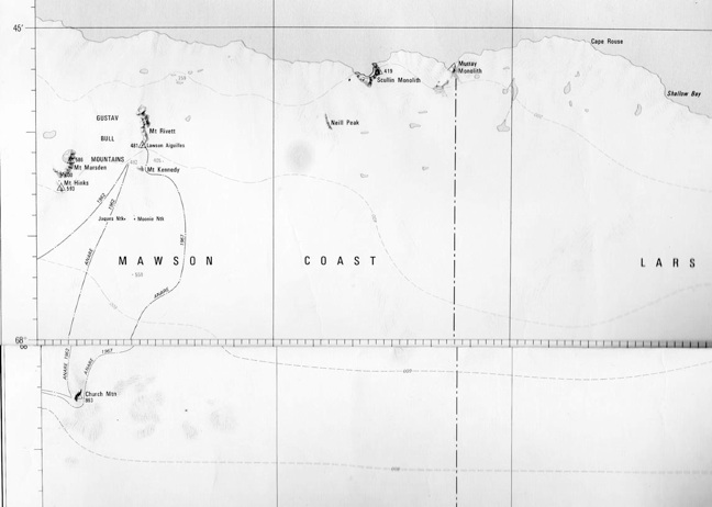
David’s first tour of duty departed early in January 1961 and returned to Australia at the end of March 1961. After hydrographic surveys were carried out at Davis and Mawson, along with other station duties, the expedition ship, Thala Dan, then travelled west around the coast, retracing Mawson’s visits to that area in 1929 to 1931 and trying to get into the continent at a variety of places for landings and astrofixes. The first astrofix was west of the 45 degree east longitude just west of the boundary of the Australian territorial claim.
This astrofix was at 44 degrees east longitude. The ship was stopped by fast ice fifteen miles off-shore. This astro was to fix the position of the coastal mountains which were visible but too far distant for a landing. The fix was done with the theodolite set up on solid sea-ice, then using triangulation to fix the position of the mapping reference point. That mountain was subsequently named Carstensfjella (fjella being mountain in Norwegian). The westerly fix used the sun only, morning and afternoon observations, and indicated a shift in the mapping of that coast by about 13 miles. The theodolite was on very slightly undulating sea-ice but the result agreed with sextant observations by the ship's officer..
On this voyage, a second astrofix was achieved at 46 degrees east observing several sun shots plus Canopus and Alpha Crucis. Here we were able to land on a rock feature, McMahon Island. Geology, magnetic and gravity observations were also taken.
On return to Mawson in 1962, much survey work involved mapping around the Mawson environs with many and varied tasks with little or no astronomy requirement.
Later on in the year, there was a request from Melbourne for an astrofix at Church Mountain. Yes, that is possible and by using vehicles – Melbourne signalled back to say it was considered too dangerous for vehicles; but you can take dogs. So the dog teams were used.
It is in the work into unvisited areas that the use of astronomy is so important. The preferred method of steering a course is by Astrocompass or Sun Compass. The magnetic variation at Mawson is 60 degrees west and the horizontal component of the magnetic field is weak and a compass takes time to settle. Theodolite observations for position are applied along the way, in addition to the Mapping Astrofixes taken. It is wise to limit travel to the times when the sun is visible and shows a shadow on the astrocompass. Crevasses and rough surfaces are more discernible in these conditions. Note that in summer twenty-four hours of sunlight is available.
Church Mountain was 100 miles east of Mawson and we were to travel on the plateau. The danger was crevasses. The route to be used is on the edge of the plateau where crevassing is most prevalent. Crevassed areas can be spotted ahead – they tend to be on domes. If there is a dome or rise in front of you, you go round it. There were two attempts at this trip, having had difficulty with blizzards and tents within the first twenty miles of the first journey.
On the second attempt, it took two weeks to get to Church Mountain. Blizzard conditions once again slowed progress on this successful attempt. Crevassed areas were safely avoided. The first astrofix was completed at Church Mountain and a second one at Mt Kennedy, north of that.
This survey work was done in September. It was bitterly cold – minus 29 F at night. Observing stars meant being set up outside the tent and then diving into the tent to warm up hands over the primus. The booker sat in the tent with the primus burning and the radio man trying to receive time signals from WWV. Good stars to observe were Canopus, Fomalhaut, Alpha and Beta Crux and Antares. Diary entries record great difficulty with the cold. Night stars could be observed but batteries in the lighting set for the theodolite had to be warmed.
The return trip took only one week. This was a successful trip and it was a great experience to travel with dogs to achieve the result.
After the dog sledging journey to Church Mountain, there was limited time to prepare for the major field expedition. The task was to see if vehicles could be driven to the Amery Ice Shelf, examining the terrain with a view of future detailed studies of the Ice Shelf. The journey commenced late in October 1962 for a three month trip covering 1350 miles (2170 Kilometres). There were eight in the Party: David Carstens as Surveyor was the leader, Peter Trost, who had finished his scientific work on the station (auroral physicist), Mark Single (diesel mechanic), John Freeman (electrician) and Ted Foley (meteorologist) formed the vehicle team and then the dog team of Ian Landon-Smith (glaciologist), Kevin (Mumbles) Walker (assistant cook) and Ross Harvey (radio operator) were the dog party.
This was a major overland expedition requiring navigation route marking and recording, heighting, glaciology and meteorological recording. The traverse was into territory not previously visited on the ground.
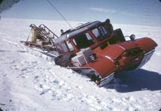
Travel was with two D4 Caterpillar tractors towing sledges and a caravan, a Snowtrack, plus two dog teams of seven dogs each. In autumn a party led by OIC Mike Lucas had travelled from Mawson to establish Depots A and B. Depot B was 150 miles, about the half way mark to the Ice Shelf. It was 300 miles to the final Depot set up on the Shelf. From that Ice Shelf depot (Depot E), the dogs went south along the centre of the Ice Shelf taking glaciology observations and the Snowtrack headed for the western edge of the Ice Shelf to examine conditions and map the features. The D4s, sledges and caravan stayed at Depot E.
From Depot E the glaciology team of Landon-Smith, Walker and Harvey had a successful run to near the junction of the ice shelf with the Lambert Glacier. A theodolite was used for ice movement measurements as well as navigation.
Two people (Freeman and Foley) stayed at the Depot. Single, Trost and Carstens went with the Snowtrack travelling west and south, found a rock feature.
In trying to get to Jetty Peninsula we were blocked by serious crevassing and returned to Depot E. This was after having two episodes of the Snowtrack collapsing sideways into a bridged crevasse, because it was invisible on the surface, and the necessary recovery operations of digging and hand winching.
The only mapping astrofix on this major trip was on the rock feature on the edge of the Amery Ice Shelf, now named Trost Rocks. Other theodolite fixes were done for navigation purposes. All the party returned to Mawson mid-January having celebrated Christmas out in the field.
On their return to Mawson, there was one more field task to undertake. It was getting close to the arrival of the relief ship, but Rex Filson and John (Snow) Williams volunteered to assist with an Astrofix about forty miles inland ― now mapped as Anniversary Nunataks. This was a five day exercise in Snowtrack No 1 and involved a trip of 90 miles. The astrofix was achieved on Australia Day. Van Hulssen Nunatak was climbed, lichens collected and the team arrived back at Mawson four days before the ship arrived.
Their trips out of Mawson were done without any possibility of air support. Had there been any problem with machines, especially on the Amery traverse, the dogs were their rescue system for return to Mawson.
After they left Mawson, with Dr Phillip Law, then Director of ANARE, and who was Voyage Leader on the Nella Dan, they set out to map the front of the Amery Ice Shelf from the ship starting at Cape Darnley, through Mackenzie Bay to Prydz Bay. The final astrofix was taken at a landing on the edge of the ice shelf and this showed the the front of the shelf had moved forward about five miles in the previous five years when compared with a previous astrofix by the Russians. This value for movement of the Shelf has been confirmed by subsequent studies.
This was fifty years ago. Today GNSS navigation makes surveying it all so much easier, but there remains the need for older navigation methods in the event that GNSS fails. With modern equipment, aeroplanes and helicopters, mapping work which took three months can be done in days. However over snow travel with heavy equipment is still required and climatic challenges are the same.