During the post World War Two years the Australian Army played a significant role in mapping the Australian continent. Perhaps slow to start due to limitations of both technology and personnel and other national development commitments, by the mid 1950s the need to map Australia at a consistent scale became paramount in the interests of national development and also defence.
Existing topographic mapping in 1950 comprised mainly of maps at the scale of four miles to an inch, many produced as emergency maps by the survey offices within each state’s land’s departments from their property maps supplemented by ‘travellers tales’. Pockets of inch to the mile maps more accurate maps from the 1920s and 1930s existed near centres of population and in strategic areas such as of the north Queensland coast and the Northern Territory, the latter produced by the Army during the war.
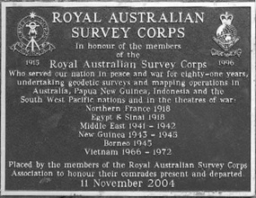
It was the Royal Australian Survey Corps, raised in 1915 that carried the mapping responsibility. Ideally mapping across the continent should be based on a single datum or point of origin such that (in simplistic terms) maps produced extending eastwards from, say, Perth meeting maps extending westward from, say, Sydney would actually meet and join. This obvious need could only be met by establishing a network of coordinated positions across the whole of the continent and until the advent of electronic distance measurement in the 1950s, the only technique for doing this was by the traditional method of triangulation.
Australia is a remarkably flat continent and the hills necessary for observing and measuring angles to form a chain of triangulated figures simply did not exist over large areas of the continent, however, in limited areas where mountain ranges did exist, triangulation was being carried out, for example, the Queensland coast.
Provided mapping is at a small enough scale, for example the old imperial scale of four miles to one inch or its metric equivalent of a centimetre to two and a half kilometres (1: 250,000), the need for precise accuracy in ground position determination is much less.
The 1: 250,000 mapping of Australia was based on astronomical observations for position with each point so determined connected by ground measurement to a point of detail that could be identified in air photography. Map detail was obtained from air photography. Star observations were carried out at night to establish the observer’s latitude and longitude, the latter requiring the use of an accurate chronometer and radio equipment to tune into national and international radio time signals.
A ground positional accuracy of thirty metres could be obtained this way, more than adequate for mapping at the scale of 1:250,000. Four sets of observations would normally be carried out on a star that was listed in the Surveyors Star Almanac for its coordinates on the celestial sphere, that is, its declination and its right ascension. Stars could be identified in the heavens using a star chart – Norton’s Star Atlas was preferred. Position would be calculated the following morning for each set of observations and provided the result of each set fell within a tolerable range, say ten seconds of latitude and longitude the mean of the four sets would be adopted as the coordinated position of that point. It was then on to the next observation point.
It was sometime in the 1970s that Australia was proclaimed to be totally precisely mapped at the scale of 1:250,000 and the day that was proclaimed was certainly one of significance.
But 1:250,000 mapping was not the only work that the Royal Australian Survey Corps was undertaking during that period. As well as the 1:250,000 map coverage of the continent the second objective was to map a 250 kilometre wide band measured inland from the coast at a scale of 1:100,000, that is where a centimetre on the map is a kilometre on the ground.
The 1:100,000 mapping was to show ground shape by contours. Only some of the 1:250,000 maps were contoured. Astronomical observations for position were not sufficiently accurate for 1:100,000 mapping. A more precise method of position fixing had to be used; for example, triangulation. However, triangulation by itself would have been incredibly difficult and time consuming.
Electronic distance measurement had been in the wind from about 1955 but it wasn’t until 1957 that a practical device was invented that was sufficiently portable to be deployed to the field. That equipment was the ‘Tellurometer’. The Tellurometer could measure distances of up to 30 kilometres to an accuracy of a few centimetres. The measurement was based on the exact speed of light which had been determined in the early 1950s although the Tellurometer used radio waves.
In 1957 the Survey Corps purchased a number of Tellurometers and throughout that year extensive field testing was carried out in Victoria over lines that were of known length determined by triangulation. At the same time in 1957, a section of the Corps was continuing with triangulation in the coastal range of Queensland with similar work in the other states and in the then Territory of Papua and New Guinea (New Ireland). Astronomical observations for position and azimuth (line bearing) were a major undertaking on that latter project, a very difficult task in tropical areas where clear skies at night are at a premium.
Tellurometer traversing in earnest commenced in 1958 across all states of Australia, not only by the Army units but also with the Commonwealth mapping agency, the Division of National Mapping.
In Queensland traverses were measured up the coastal range through the older triangulation chains and one very significant traverse was carried out across Queensland from Charters Towers to Tennant Creek to meet the traverse carried out by the Division of National Mapping through the centre of Australia; Alice Springs northwards.
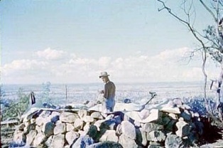
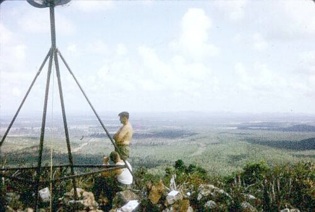
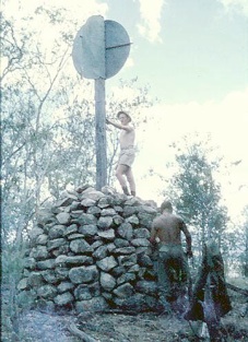
In addition to line measurement the included horizontal angle at each traverse station had to be measured with a high precision geodetic theodolite and also vertical angles to the adjoining stations. The horizontal angle measurement took place at night to pin-points of light on the adjoining stations.
Very high levels of precision had to be obtained on traverses of this nature in both distance measurement and angle observation. In those early years it was hard but adventurous work requiring heavy loads of equipment to be carried on trapper’s packs to hill tops. Very precise astronomical azimuths were required on selected lines together with position in latitude and longitude.
Field astronomical stations of this nature were called ‘Laplace Stations’ after the French mathematician and astronomer, Pierre Laplace (1749-1827). For Laplace observations, an astronomical theodolite capable of being read to half a second of arc was used with time recording equipment comprising an accurate chronometer slung in gimbals, high frequency radio equipment for tuning in to an international continuous time signal and a chronograph that registered on continuous tape with a blip each second of time as well as the moment the star being observed crossed the wire of the theodolite telescope. The observer in fact tracked the star with a moveable vertical wire across the field of view within the telescope.. The observations themselves were carried out within a small tented observatory erected around the station. The Surveyor’s Star Almanac was not sufficiently precise in its tables of right ascension and declination. For Laplace work star coordinates were obtained from the ‘Fundamental Catalogue of Stars (FK4-FK6), a voluminous international publication.
From 1958 through to the mid 1960smid-1960s, Tellurometer traverses snaked their way across and around the continent. In Queensland the coastal traverse extended from New South Wales to the Torres Strait; another from Mount Isa to Borroloola then to Mount Hensman in Western Australia, from Bourke in New South Wales to Charleville. Where no hills existed, towers were constructed to provide for lines of 15 to 20 kilometres in length. The Army used ‘Bilby Towers’ that were in effect two towers – an inner tower and an outer tower independent of each other such that the theodolite was bolted to the inner tower and the observer stood on a platform on the outer tower. Bilby towers could be built to a height of 70 feet (22 metres). Once observations were completed the tower would be dismantled and moved to the next location.
Tellurometer traverses of this nature were not directly related to mapping. They were geodetic traverses the primary purpose of which was to determine the parameters of a mathematical figure, a spheroid that best fitted the true shape of the Australian geoid, that is, the actual shape sea level would take if it extended over the whole continent. From these determinations a more adequate mathematical shape could be deduced best suited to the Australian continent defined by its semi major axis and semi minor axis and degree of flattening.
Subsequent mapping at any scale could then be positioned within this early geodetic framework and be totally consistent across the whole continent such that when maps extending westward from Perth connected with maps extending westward from Sydney they would exactly meet and join without gaps or overlaps.
Many of these concepts have been overtaken by advancing technology, paper maps themselves have been superseded by digital data bases. The use of artificial satellites (GNSS) now determines position to an incredible exactitude in real time. While the arduous and exacting work undertaken by surveyors from Army, the Commonwealth and State departments during the decades of the 1950s, 60s and into the 70s has long been superseded, without it, modern technologies of instantaneous positioning over the entire surface of the earth may not have been achieved.