Transit of Venus Australia 2012

Australian Surveyors and Spatial Scientists
“The strength of the Australian economy is underpinned by a system that relies on the integrity and skill of Surveyors, without Surveyors Australia’s development stops.” www.acsnational.com.au/
Surveyors and Spatial Scientists observe and record the position of features, heights, contours, boundary lines (Cadastral Surveying); they can set out works or provide information for architects and engineers to
prepare their designs. They provide the necessary expertise to determine legal title definition, development and subdivision and professional advice about land tenure. The map base used by your car’s navigation system
or when you undertake a search on Google Maps, looking for property, providing location information of our essential services or simple apps on your iPhone requiring a GPS position fix, owe their existence to the
underlying work of Surveyors and Spatial Scientists.


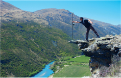
Discover a Life Without Limits...
Surveyors and Astronomy and the future.
Astronomy is the oldest of the natural sciences dating back to ancient Chinese and Babylonian civilisations. It can be defined as the science that deals with the universe beyond the Earth.
Navigators, explorers and surveyors have used astronomical observations to determine their position on the Earth (latitude and longitude). Early surveyors, not only had skills in bushcraft, navigation and mapping, but they also required knowledge of mathematics and astronomy in addition to an understanding of the land and its potential.
The surveyor’s interest in astronomy was very much a practical one. Unlike the astronomer with a scientific interest in the stars, a surveyor was interested in how the stars could be used for the purpose of positioning on the Earth.
Surveying skills were an essential component of early Transit of Venus expeditions. It was often necessary to put more effort into the accurate geographic positioning of the observing location than into actually observing the transit. And it was often the case that a person with surveying expertise would complete the mathematical analysis of the observations. Over the years, the work of surveyors using astronomy has been superceded by more modern positioning technologies such as the Global Positioning System (GPS). However the Transit of Venus observations which computed the scale of the solar system have provided the foundation of Modern Geodesy which impacts our lives in so many ways today.
Surveyors and Spatial Scientists
This articles contributing authors are Peter Swan (DERM, QLD.), Bob Ross (DSE, Manager of the Geodetic Survey Section (retired), VIC.), Connie Beadell ( www.beadelltours.com.au Daughter of Len Beadell Surveyor and explorer SA. and WA.) Compiled by Peter Swan. January 2012
What is Surveying?
Surveying is the measurement and mapping of the environment using maths and specialised technology. Surveyors measure just about anything on the land, in the sky or on the ocean bed.
What do Surveyors do?
Surveyors work in “suits and boots”.
Out in the field, Surveyors use the latest technology including high order GPS, Robotic Total Stations (Theodolites), aerial and terrestrial scanners to map and measure an area, making computations and taking photos as evidence. In the office, Surveyors then use sophisticated computing software, Auto-cad and other mapping software to draft plans and map the onsite measurements.
Surveyors work on a diverse variety of projects from land subdivision and mining exploration, to tunnel building and major construction. They are experts in determining land size and measurement. They give advice and provide information to guide the work of engineers, architects and developers.
What is Surveying and Spatial Science?
Surveying is related to the broad areas of Spatial Science or Geospatial Science.
Spatial means “the relative place or location of something”. Spatial Science helps to understand the relationship between the community and the environment to help predict trends and patterns. Surveying is first done to establish the boundaries, and Spatial Technologies are used to interpret and report on the data.
This data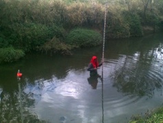 is used whenever we search on Google Maps or track a location on a GPS unit. Other Spatial professionals will use the data to help establish trends or predict changes to the environment such as the spread of the Queensland Floods in 2011.
The main types of Surveying specialisations are Land, Mining, Engineering, Hydrographic.
Other Spatial Science fields include Geodesy, Topographic Surveying, Remote Sensing, Geographic Information Systems (GIS)
(for more information go to www.alifewithoutlimits.com.au or http://www.destinationspatial.org )
Why should I consider becoming a Surveyor?
Surveying is the perfect career for those who are good at maths, have an interest in the environment, geography, science and IT, plus enjoy the variety of being indoors and out.
It also helps to have enjoy problem solving, and working both independently and as part of a team.
There is a shortage of Surveyors across Australia, and even across the world, so the demand for graduates is high.
Career Pathways
You can start working in a Surveying firm with a Certificate in Surveying or Geospatial Science, or while you are at University doing a Surveying Degree. Graduate Surveyors can do an additional Industry qualification to “License” them to sign legal documents submitted to Land Registry and Titles Offices.
(more information on where to study – go to:
http://www.alifewithoutlimits.com.au/study/student-life/
http://www.destinationspatial.org/explore.aspx
History of Surveying
The first land surveys date back to nearly 3,000 years ago, when Egyptian Surveyors subdivided the land around the Nile River.
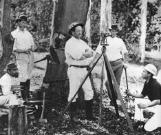
The early explorers of Australia like Burke and Wills had a Surveying background which allowed them to divide land accurately.
Back then, Surveyors used chains and steel bands, which made their measurements difficult to record and often required the use of logarithmic tables and slide rulers.
New Technology
The advancement of new technology means Surveyors can now take measurements and report data with increased speed and accuracy.
Surveyors use equipment like total stations, worth upwards of $50K, to electronically calculate distances 100’s of metres away. Robotic versions are also available, allowing Surveyors to single-handedly operate a total station by remote control.
(more information http://www.alifewithoutlimits.com.au/about-surveying/technology/ )
Try Surveying
Try Surveying promotes the Surveying Industry as a career of choice. It is made up of Industry, Government and Tertiary representatives. They provide teacher resources and work experience opportunities for youth.
See: www.alifewithoutlimits.com.au
See also: www.destinationspatial.org
See the new Careers video for more information: 

All the information and images in this web site are protected by Creative Commons Copyright unless otherwise noted.